

$45
/person25% Off
Suspension Bridge
Quisque cursus finibus lectus, at dignissim mi congue ac.
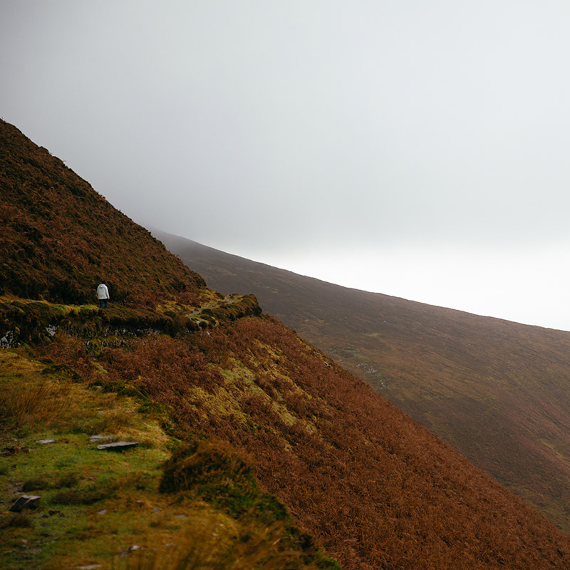
Drung Hill rises straight up from the sea. It’s a less-frequented portion of the Kerry Way, but this is its charm. On a clear enough day, you can find yourself alone for miles with panoramic views that take in South Kerry, West Kerry and the Reeks District.
On an overcast day, this hike is like walking along the edge of the world. After the initial climb, the path levels out and hugs the side of the hill, which drops dramatically on your right. As you progress, there is nothing below the steep drop but the immensity of the ocean.
The path you follow is visibly rutted, having been used as a stagecoach road until the 1800s. Over Mountain Stage, you can see tunnels where the train once made its way to Valentia Island in the 20th century, parallel to the modern Ring of Kerry Road further down. On the shoulder of Drung, turn left, leaving behind the Kerry Way. A steep climb through heather will bring you to a cairn on the summit where you can see Valentia Island, the Dingle Peninsula, Castlemaine Harbour, the sand bars of Inch Beach and Rossbeigh Strand, Curra Hill and MacGillycuddy’s Reeks beyond.
Drung comes from the Irish for a gathering of people. The ogham stone near the summit marks the spot where people used to gather for religious pilgrimages in the medieval period and probably earlier.
From here, you can call it a day and turn back, but if you have enough time, you can continue on to Beenmore and walk along the lip of Coomasaharn Horseshoe, which overlooks Coomasaharn Lake.
The start of the trail was once a coach road that now forms part of the Kerry Way.
There's an ogham stone at the summit where people gathered for religious pilgrimages in the Middle Ages.
From Drung Hill, you can look down and see tunnels where the railroad to Valentia Island ran until 1960.
The path was part of an old Butter Road where people transported firkins from South Kerry to Cork.
Drung Hill is on the OSI Discovery Series 78 map.
A sandwich and a flask of tea. The nearest place to get food is in Glenbeigh.
Wear proper hiking boots as the trail can be quite muddy and bring a rain jacket because the weather is anyone’s guess.
From Killorglin, take the 279A bus toward Caherciveen/Waterville and ask the driver to stop at Mountain Stage outside of Glenbeigh.
It’s a 20 minute walk from the bus stop to the trail start.
We love seeing what you get up to. Share your #ReeksDistrict photos and tag @reeksdistrict to be featured

We are a co-operative of 100+ small Irish family businesses. Supporting this project helps support both our region and all our members.
The Reeks District is a not-for-profit organisation that includes 100+ small local businesses. By visiting us, you help support both our region and all our members.
| Cookie | Duration | Description |
|---|---|---|
| cookielawinfo-checkbox-advertisement | 1 year | Set by the GDPR Cookie Consent plugin, this cookie is used to record the user consent for the cookies in the "Advertisement" category . |
| cookielawinfo-checkbox-analytics | 11 months | This cookie is set by GDPR Cookie Consent plugin. The cookie is used to store the user consent for the cookies in the category "Analytics". |
| cookielawinfo-checkbox-functional | 11 months | The cookie is set by GDPR cookie consent to record the user consent for the cookies in the category "Functional". |
| cookielawinfo-checkbox-necessary | 11 months | This cookie is set by GDPR Cookie Consent plugin. The cookies is used to store the user consent for the cookies in the category "Necessary". |
| cookielawinfo-checkbox-others | 11 months | This cookie is set by GDPR Cookie Consent plugin. The cookie is used to store the user consent for the cookies in the category "Other. |
| cookielawinfo-checkbox-performance | 11 months | This cookie is set by GDPR Cookie Consent plugin. The cookie is used to store the user consent for the cookies in the category "Performance". |
| CookieLawInfoConsent | 1 year | Records the default button state of the corresponding category & the status of CCPA. It works only in coordination with the primary cookie. |
| elementor | never | This cookie is used by the website's WordPress theme. It allows the website owner to implement or change the website's content in real-time. |
| PHPSESSID | session | This cookie is native to PHP applications. The cookie is used to store and identify a users' unique session ID for the purpose of managing user session on the website. The cookie is a session cookies and is deleted when all the browser windows are closed. |
| viewed_cookie_policy | 11 months | The cookie is set by the GDPR Cookie Consent plugin and is used to store whether or not user has consented to the use of cookies. It does not store any personal data. |
| Cookie | Duration | Description |
|---|---|---|
| _ga | 2 years | The _ga cookie, installed by Google Analytics, calculates visitor, session and campaign data and also keeps track of site usage for the site's analytics report. The cookie stores information anonymously and assigns a randomly generated number to recognize unique visitors. |
| _gat_gtag_UA_113644918_1 | 1 minute | Set by Google to distinguish users. |
| _gid | 1 day | Installed by Google Analytics, _gid cookie stores information on how visitors use a website, while also creating an analytics report of the website's performance. Some of the data that are collected include the number of visitors, their source, and the pages they visit anonymously. |
| _hjAbsoluteSessionInProgress | 30 minutes | Hotjar sets this cookie to detect the first pageview session of a user. This is a True/False flag set by the cookie. |
| _hjFirstSeen | 30 minutes | Hotjar sets this cookie to identify a new user’s first session. It stores a true/false value, indicating whether it was the first time Hotjar saw this user. |
| _hjIncludedInPageviewSample | 2 minutes | Hotjar sets this cookie to know whether a user is included in the data sampling defined by the site's pageview limit. |
| _hjIncludedInSessionSample | 2 minutes | Hotjar sets this cookie to know whether a user is included in the data sampling defined by the site's daily session limit. |
| Cookie | Duration | Description |
|---|---|---|
| NID | 6 months | NID cookie, set by Google, is used for advertising purposes; to limit the number of times the user sees an ad, to mute unwanted ads, and to measure the effectiveness of ads. |
| Cookie | Duration | Description |
|---|---|---|
| _hjSession_2843468 | 30 minutes | No description |
| _hjSessionUser_2843468 | 1 year | No description |